By Peter Douglas
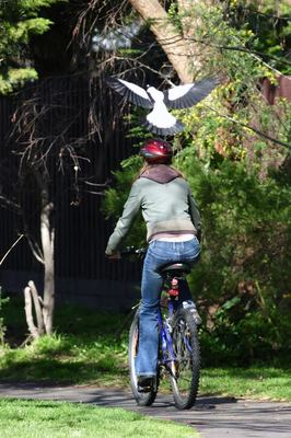
ANYONE who has endured an attack from a swooping magpie knows it can be a terrifying experience.
Particularly if the victim has been caught off-guard.
Which is why the Department of Environment, Land, Water and Planning (DELWP) has come to the rescue with a new tool to help walkers avoid a tussle with an Australian icon.
During the spring breeding season, the 2016 Magpie Map shows locations where people have been swooped.
The map encourages people to log details about swooping hotspots, including the location and comments about the attack.
Within the Yarra Ranges, swoops already logged include at Myers Creek Road, Healesville; Falls Road, Olinda; Steels Creek Road, Yarra Glen; and King Street, Yarra Glen.
Meanwhile, one poster who logged an incident at Warburton mused the magpie must have been a pterodactyl, joking the magpie was large enough to pick up a small child.
Magpies are renowned for being protective of their young and often swoop if they feel threatened.
According to DELWP, it is important to know your local swooping hotspots so you can avoid the area, or know to move quickly through the area.
If you do need to walk through a known hotspot, make sure to cover your head with a hat, or carry a stick or umbrella above your head.
Cyclists are advised to wear a helmet, but dismount and walk through the area.
While many understandably view swooping magpies as a nuisance, it is important not to interfere with their habitat or throw stones.
To view the 2016 Magpie Map, visit http://www.delwp.vic.gov.au/environment-and-wildlife/wildlife/swooping-birds.


