Yarra Ranges Council is inviting community feedback on proposed updates to the Erosion Management Overlay (EMO) mapping in the Yarra Ranges Planning Scheme.
The consultation period will run from 21 August to 3 October, and residents impacted by the proposed changes will receive a letter with further details about how to make a submission.
This consultation phase, called ‘exhibition’ is one of several steps in the amendment process, which also includes consideration of submissions by an independent Planning Panel (if required), and final approval by the Minister for Planning.
Once the amendment is approved and gazetted by the Minister, the new provisions will come into effect in the Planning Scheme. Affected residents will be notified when this happens. Amendments can be a lengthy process, taking a year or more.
To support the community, Council will hold a range of information sessions during and outside office hours across the municipality. These will include in-person sessions with a geotechnical expert, webinars with a geotechnical expert, and bookable drop-in sessions with council planners.
To find out where and when these sessions will be held, to register to attend and to make a submission, visit shaping.yarraranges.vic.gov.au.
Originally implemented into the Yarra Ranges Planning Scheme in 2001, the EMO mapping has now been revised using advanced LIDAR technology and updated geotechnical assessments. These updates align with the Australian Geomechanics Society’s 2007 Guidelines for Landslide Risk Management, providing a more accurate understanding of landslip risks across the municipality.
Yarra Ranges Mayor Jim Child said the update is a vital part of Council’s responsibility to maintain a current and effective planning scheme.
“We know how important it is to protect our community from natural hazards. This update ensures that our planning controls reflect the latest science and technology, helping us manage landslip risks more effectively,” Cr Child said.
“The EMO only applies to new development, earthworks, subdivisions or extensions or re-building a home. It’s about making sure future development on your property is safe and sustainable for you and your neighbours.”
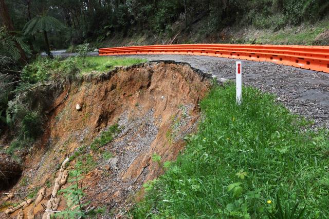
The EMO is a state-wide planning control designed to minimise land disturbance and inappropriate development in areas prone to erosion and landslip. The updated mapping has identified 1,183 recorded landslides across the municipality.
As part of the proposed Planning Scheme Amendment (C225), the council will notify all property owners affected by changes to the EMO mapping.
This includes 937 properties proposed for removal from the EMO, 3259 newly identified properties added to Schedule 1 (landslip hazard), 290 properties added to Schedule 2 (debris flow hazard), plus 209 already included in the EMO and 202 properties included in both Schedules.
Total properties within the EMO will increase to 13,724, a net increase of 2365.
If you already have an EMO on your property, it’s important to note that there are a few minor changes. This is mainly that there are now two schedules, one for landslip and one for debris flow and there are some minor grammatical corrections and permit exemption for repairs and maintenance works to existing assets by public authorities.
“We’re committed to transparency and community engagement throughout this process. Residents will have multiple opportunities to learn more, ask questions, and make a submission on the proposed mapping changes or wording in the EMO schedules,” Cr Child said.
Community Consultation
The formal consultation period will run from 21 August to 3 October 2025. During this time:
Impacted property owners and occupiers will receive letters with details on how to make a submission.
Notices will be published in local newspapers.
Information will be available on the council’s and the Department of Transport and Planning’s websites including an online mapping tool.
You must make your submission in writing at www.shaping.yarraranges.vic.gov.au or by email to mail@yarraranges.vic.gov.au with C225 in the subject line, or in the post to Design and Place, Yarra Ranges Council, PO Box 150, Lilydale 3140 (Quote Amendment C225).
Submissions can support or seek changes to proposed planning scheme changes.
Submissions are most effective when they demonstrate how a proposal may impact the individual making the submission.
All submissions will be considered and summarised in a report to Council. Submitters will be notified of the Council meeting and may also present to Council and an Independent Panel appointed by the Minister for Planning, if required.
Submitters name, address and submission may become public as part of this amendment. As this is a legislated process, submissions received outside the consultation dates cannot be accepted.
For more information, visit: yarraranges.vic.gov.au/C225, shaping.yarraranges.vic.gov.au/c225 or contact Council’s Strategic Planning team on 1300 368 333.