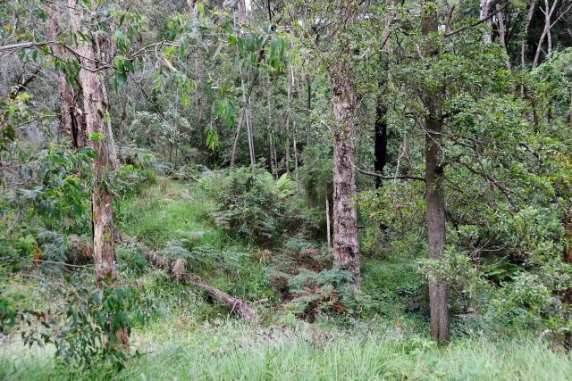
A local family has raised concerns about vegetation growing in a gully behind their Belgrave Heights home, labelling the condition of the bushes a “bushfire risk”.
The family, who chose not to be named, said the gully, which runs 30 metres across their property and about three or four metres deep is “thick with weeds“ and has not been properly maintained.
They said CFA, and Yarra Ranges Council – who manages the land – has claimed the vegetation is just “wet undergrowth“ and will not clear it from the gully.
“It is now overgrown and they claim that it’s only got ground cover on it,“ the family said.
“It has been a wet season, but now they’re saying we’re going to have a hot summer, and if we have a hot summer and all of that growth dries out and a fire starts in there, it will be a real danger to all the houses on either side.
“There’s 20 houses backing onto this gully from both sides, which will all be under threat if it was to happen.“
They said the ground fuel is as high as the gully.
“On Ash Wednesday, the gully didn’t have anything to hold it in; there wasn’t anything left in the gully and it didn’t collapse – it’s just overgrown.”
Yarra Ranges Council’s director of planning and sustainable futures, Kath McClusky, said council staff have engaged with a “number of residents” whose properties border the gully, offering professional advice on past and future vegetation management efforts.
“In recent months, regional CFA vegetation management staff also attended one of these meetings to provide additional professional advice to the resident,” Ms McClusky said.
“Over the past decade, Council has actively pursued vegetation reduction measures in partnership with District 13 CFA, consistently maintaining the area at a lower risk level through annual pre-fire season initiatives and year-round vegetation management.
“The approach in managing vegetation growth is influenced by the gully’s steep terrain, which is prone to slumping, necessitating a balance in vegetation for soil stability.”
Ms McClusky said the area’s “riparian classification” and “above-average moisture levels” are also key factors.
“Council utilises State Government endorsed assessment tools to assess risks and prioritise fuel reduction in areas closest to residents’ homes,” she said.
“The safety of our community is a top priority for Council, and we collaborate closely with District CFA to implement vegetation management burns (fuel reduction burns), ensuring a proactive approach to bushfire preparedness.
“Additionally, we consistently engage in the ongoing preparation and management of sites throughout the year to manage fuel loads.”
At the last council meeting, Ms McClusky said, all 18 designated Neighbourhood Safer Places – Places of Last Resort, while include three Community Fire Refuges commissioned by Emergency Management Victoria, have been “thoroughly assessed” and are confirmed as ready to serve as last resorts for the community during the upcoming 2023/2024 fire season.
CFA would not provide comment to the Star Mail due to the land in question being managed by Yarra Ranges Council.

