By Callum Ludwig
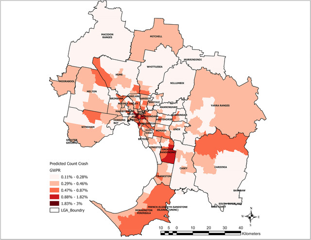
A new study from Flinders University is calling for better policies and practices to be implemented to improve road safety, with the ‘mountainous’ Yarra Ranges and Cardinia identified as likely hotspots for increased road crashes in the future.
Dr Ali Soltani and his research colleagues from the Flinders Health and Medical Research Institute analysed the trends and locations of crashes in the Greater Melbourne Area between 2006 and 2020.
Dr Soltani and his colleagues used the data over the 15-year period to determine the most common places for crashes and likely reasons for the high crash rates.
Dr Soltani said road safety has been a policy priority in Australia for decades but the rate of road transport injuries is not declining.
“While the Australian Federal Government and State Governments have introduced policies and initiatives including road safety campaigns, infrastructure improvements, speed restrictions and graded licencing process – along with imposing safety regulations for vehicles sold in Australia, as well as sanctions and repercussions for reckless driving – we still see that traffic crashes remain alarmingly high,” he said.
Dr Soltani also noted that hospitalisation rates have increased in the last nine years and there has been no decline in hospitalisations where there’s a ‘high threat to life’ despite continuous pushes for road safety improvements.
Researchers developed a Tweedie distribution model to examine how crash frequency and potential contributing factors such as socio-demographics, road transport infrastructure and the built environment interact to predict road crash rates and create risk ratings for the different local government areas in Melbourne in an effort to offer insight into where road safety action should be prioritised and what initiatives should be implemented.
Dr Solanti said investigating road crash temporal and spatial patterns are essential to build better prevention strategies that target high-crash times and areas, distribute resources more efficiently, improve emergency response times, and assess road safety initiatives.
“Analysing the space-time data may improve Victorian policy and support evidence-based actions for a safer, more resilient transportation infrastructure,” he said,
“Special land use activities such as commercial and parkland can affect road safety, and knowing how built environment variables contribute to crashes can help building safer roads and minimise injuries and deaths.”
To reduce the frequency of road crashes, researchers are calling for a comprehensive strategy to address the effect of built environment on road traffic crashes and for critical measures such as lowering speed limits in local streets to be implemented.
“It is anticipated that downtown Melbourne will continue to be the primary location for crash hotspots, while the inner suburbs are expected to have a decrease in the occurrence of crashes, thereby enhancing safety levels,” Dr Soltani said.
The study names Knox as one of the LGAs with the strongest overall downward trend in accident frequency from 2016 to 2021.
The Star Mail contacted the Victorian Department of Transport and Planning (DOTP) for a response to the study.
“Keeping Victorians safe is our number one priority that’s why we’re working closely with police and councils to improve road safety across our communities,” a DOTP spokesperson said.
Road safety projects recently delivered in the Yarra Ranges and Cardinia areas have consisted of upgrades to pedestrian crossings, electronic speed limit signage in busy areas, rumble strip line markings, safety barriers, and shoulder sealing.
The DOTP has also committed $210 million to the Safe Local Roads and Streets Program to support local councils to deliver safety improvements on high-risk local roads, intersections, and precincts.
The research – “Space-time analysis of accident frequency and the role of built environment in mitigation”, by Ali Soltani and Mohsen Roohani Qadikolaei – has been published in the Transport Policy journal and can be viewed at doi.org/10.1016/j.tranpol.2024.02.006.


