
By Romy Stephens
Cooler temperatures and more rainfall is expected in the Yarra Ranges towards the end of this year, with the Bureau of Meteorology declaring a La Nina.
La Nina is the cool phase of the El Nino Southern Oscillation. It typically means above average spring rainfall and cooler days in Victoria.
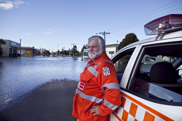
Lilydale State Emergency Service (SES) unit controller Shaun Caulfield said locations such as Yarra Junction, Yarra Glen, Healesville, Warburton, Lilydale and Mooroolbark were particularly susceptible to flooding.
But Mr Caulfield said most residents within the municipality should be prepared.
“We know that a La Nina usually results in unseasonably heavy rainfall, particularly during spring and sometimes into summer,” he said.
“We are very focused on fire in the valley because we see it as an immediate threat.
“We get very complacent around floods because we don’t necessarily see the life threat from floods, but it is certainly possible.
“We can prepare for floods just like we can prepare for fires.”
Mr Caulfield also warned of potential increase in the risk of trees falling.
“When the ground is wet you don’t need as much wind to make trees fall down,” he said.
“Thunderstorms tend to bring gusty winds with them, then we do see that risk of higher tree falls.”
A La Nina event is often associated with cooler sea surface temperatures in the central and eastern tropical Pacific Ocean.
They normally last about a year, forming in autumn or winter, then decaying in late summer.
The last La Nina event occurred from 2010-2012 and resulted in one of Australia’s wettest two-year periods on record. Widespread flooding occurred in many parts of Australia, associated with the record rainfalls.
The Bureau of Meteorology’s manager of climate operations, Dr Andrew Watkins, said more rain associated with La Nina can wet up the soils and increase the risk of widespread and flash flooding.
“Typically more rainfall, wetter soils, higher rivers, more water going into our storages as well, which is a good thing in many areas but also increases the risk of flooding,” he said.
Dr Watkins said the event was likely to also impact the nature of heatwaves and bushfires.
“It reduces the risk of getting those really extreme heatwaves but, unfortunately, the heatwaves we do get tend to be longer in duration and could be more humid as well,” he said.
“In terms of fires, it reduces the fire risk a little but, of course, south eastern Australia, one of the more fire prone places in the world, we’re not going to get through a summer without seeing any fires.”
Mr Caulfield urged locals to start preparing for the changes in weather conditions now.
“Know your flood risk. Some areas have a very different risk of flood than others,” he said.
“SES has some local flood guides on the public website, they are based on the municipality…they’ll give you an idea of the areas that are prone to flooding.”
Mr Caulfield also said people can prepare for storms by securing their loose items and cleaning out their gutters.
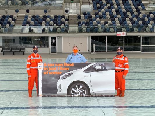
VICSES is currently running a campaign that highlights the dangers of attempting to drive through floodwaters.
15 to Float warns people that it can take just 15cm for a car to float in water.
For more information on flood risk and to find your local flood guide, visit www.ses.vic.gov.au/get-ready/your-local-flood-information.


